搜索结果: 1-11 共查到“工学 truth”相关记录11条 . 查询时间(0.125 秒)

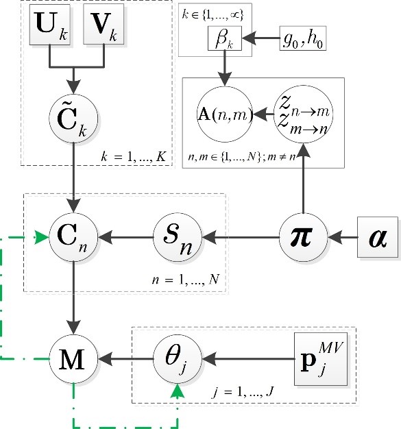
吉林大学人工智能学院杨杰龙助理教授在社交网络Truth Discovery方向取得进展(图)
吉林大学人工智能学院 杨杰龙 社交网络 Truth Discovery 机器学习 图神经网络
2022/4/6
吉林大学人工智能学院助理教授杨杰龙以第一作者发表论文An Unsupervised Bayesian Neural Network for Truth Discovery in Social Networks近日被IEEE Transactions on Knowledge and Data Engineering杂志接收。文章主要提出一种新的贝叶斯神经网络模型,利用神经网络在数据表示的灵活性以及...
SEA ICE THICKNESS MEASUREMENT BY GROUND PENETRATING RADAR FOR GROUND TRUTH OF MICROWAVE REMOTE SENSING DATA
Sea ice thickness measurement, Microwave remote sensing Ground truth Ground Penetrating Radar Brackish lake Finite-Difference Time-Domain method Dielectric constant
2018/5/15
Observation of sea ice thickness is one of key issues to understand regional effect of global warming. One of approaches to monitor sea ice in large area is microwave remote sensing data analysis. How...
GENERATION OF GROUND TRUTH DATASETS FOR THE ANALYSIS OF 3D POINT CLOUDS IN URBAN SCENES ACQUIRED VIA DIFFERENT SENSORS
Different sensors Point clouds Multi-resolution voxel structure 3D space labeling
2018/5/16
In this work, we report a novel way of generating ground truth dataset for analyzing point cloud from different sensors and the validation of algorithms. Instead of directly labeling large amount of 3...
DETECTING OUTLIERS AND ASSERTING CONSISTENCY IN AGRICULTURE GROUND TRUTH INFORMATION BY USING TEMPORAL VI DATA FROM MODIS
Multi-temporal Image Processing Land Use Crop Mapping Image Understanding Satellite Remote Sensing
2015/12/31
Collecting ground truth data is an important step to be accomplished before performing a supervised classification. However, its quality depends on human, financial and time ressources. It is then imp...
Use of Orthophotos as Ground Truth in Ikonos Image Processing
Remote Sensing Spatial Interpretation
2015/7/7
This is the first attempt to use very high spatial resolution satellite sensor data (IKONOS) on Greek landscapes. The
IKONOS imagery analysed in this study covers a hilly area close to Corinth Gulf, ...
The FAA currently uses its Automated Flight Inspection System (AFIS) to check the accuracy of Instrument Landing Systems (ILS) and other navaids. It is desirable to measure the deviations of the ILS t...
The FAA currently uses its Automated Flight Inspection System (AFIS) to check the accuracy of Instrument Landing Systems (ILS) and other navaids. It is desirable to measure the deviations of the ILS t...
TOWARDS GLOBALLY CONSISTENT SCAN MATCHINGWITH GROUND TRUTH INTEGRATION
scan matching SLAM ground control point
2015/4/1
The scan matching based simultaneous localization and mapping method with six dimensional poses is capable of creating a three dimensional point cloud map of the environment, as well as estimating the...
An Inconvenient Truth: the invisibility of Women in ICT
Inconvenient Truth invisibility Women ICT
2009/12/9
This paper presents research findings from an Australian Faculty of Information and Communication Technology (FICT) against a backdrop of declining interest amongst women in courses and careers in Inf...
专著信息
书名
“Nonmoniotonic Truth Maintenance Systems”
语种
英文
撰写或编译
作者
杨杰
第一作者单位
出版社
Journal of Shanghai Jiaotong
出版地
出版日期
1996年
月
日
标准书号
介质类型
页数
1996.06,VolE-1,No.1
字数
开本
相关项目
专家系统中知识的多重表示及推理的真值维护
A Ground-truth-data Method for the Detection of Organic Substances in Waters
A Ground-truth-data Method Organic Substances
2014/4/15
A Ground-truth-data Method for the Detection of Organic Substances in Waters。

