
�������: 1-15 ���鵽������ѧ landscape����ؼ�¼16�� . ��ѯʱ��(0.171 ��)
�й����ʴ�ѧ��ѧ������չԺ���Ծޣ���ΰ�ε�. �����ѧԺ, Remote Sensing(2019), Multimodal and Multi-Model Deep Fusion for Fine Classification of Regional Complex Landscape Areas Using ZiYuan-3 Imagery
�ڵ��ʻ���ң�����ܽ���������о�����ȡ����Ҫ��չ
2021/10/18
���գ��й����ʴ�ѧ�����ѧԺ��ΰ�θ������Ŷ��ڵ��ʻ���ң�����ܽ���������о�����ȡ����Ҫ��չ������о��ɹ������ڹ��������ڿ���Remote Sensing�������ĵ�һ����Ϊ���Ծ����ڣ�ͨѶ����Ϊ��ΰ�θ����ڡ�
LANDSCAPE VULNERABILITY ASSESSMENT USING REMOTE SENSING AND GIS TOOLS IN THE INDIAN PART OF KAILASH SACRED LANDSCAPE
KSL AHP Vulnerability Fire Flood Landslide
2019/2/27
The Indian part of Kailash Sacred Landscape (KSL) is prone to flash floods, landslides and forest fires leading to various environmental and socio-economic problems. This study aims to identify areas ...
Active compressional tectonics, Quaternary capable faults, and the seismic landscape of the Po Plain (northern Italy)
Active compressional tectonics paleoseismology seismic hazard Po Plain foredeep seismic landscape
2015/8/26
It is commonly believed that the Po Plain is an area of low seismic hazard. This conclusion is essentially a combination of two factors: (1) the historical record of earthquakes, which shows a relativ...
The study of the landscape: from a holistic approach to a social concept of knowledges
Educational History of Science Public Issues Geoethics Geomorphology Society Cultural heritage Landscape
2015/8/26
Three examples of the study and enhancement of the landscape in Italy are presented. The interdisciplinary approach to this topic is carried out not simply by juxtaposing disciplines, but by the integ...
A vector-based method for bank-material tracking in coupled models of meandering and landscape evolution
A vector-based method bank-material tracking coupled models of meandering landscape evolution
2014/4/8
Sinuous channels commonly migrate laterally and interact with banks of different strengths��an interplay that links geomorphology and life and shapes diverse landscapes from the seafloor to planetary s...
Using airborne electromagnetic data for regional stratigraphic and landscape evolution studies, Murray Basin, South Australia
airborne electromagnetic data regional stratigraphic landscape evolution studies Murray Basin South Australia
2012/3/30
The $2.67 m Frome airborne electromagnetic (AEM) survey was flown between May and November 2010 as a joint survey between Geoscience Australia (GA), the Geological Survey of South Australia (PIRSA, no...
Some regolith and landscape evolution highlights from the Murray Basin's Loxton Parilla sands
regolith landscape evolution highlights the Murray Basin Loxton Parilla sands
2012/3/30
The Loxton-Parilla Sands formation provides a well-constrained geological record of the Late Miocene �C Early Pliocene marine regression from the western Murray Basin (Miranda et al. 2009). It presents...
Research on Korean Nationality��s Rural Landscape
Korean Nationality Regional Culture Rural Landscape
2011/12/20
By analyzing the features in Korean nationality��s rural landscape, abundant precious fortune of cultural value can be explored. This paper, based on the combination of the peculiar layout characterist...
The Study on Settlement Landscape Based on Sustainable View
Daping Village Human Settlements Settlement Landscape Sustainable
2011/12/20
Based on the research of settlement landscape and field study, this paper starts with the sustainable development idea, takes the Daping village settlement of landscape design in Sichuan for example, ...
The Reconstitution of Landscape Pattern at Master Planning Level in Ankang City
Ankang City Landscape Pattern Local Features Themes of Landscape
2011/12/15
The author��s observation on the new urban form of Ankang city grounded on the landscape pattern by analyzing and evaluating the present conditions of land resources, historic cultural attractions, and...
Landscape Analysis of Typical Yao-Dong Villages on Gentle Gully Slope in Semi-Arid Loess Plateau - Case Study of Shi-Jia-Gou Village in Fen-Xi County Shan-Xi Province
Chinese Traditional Inhabitation Culture Ecological Yao-Dong Villages�� Scenes Landscape Design Principles
2011/12/20
The climate of most loess plateau gully area is continental monsoon climate. It is hot , dry, sometimes rain-storm in summer, and cold, windy, occasionally snow in winter. The summer and the winter ar...
Features of Water Landscape of Ancient Villages in Huizhou
Cultural Deposits Huizhou Ancient Village Landscape Features Naive Ecological Outlook Practical Value of Water Water Feature
2011/12/21
The water landscapes of Huizhou ancient villages present evident regional features due to geographical conditions, history and culture and construction idea. Through analysis and summary for character...
Concept and Practice of Landscape Planning and Designing on Ancillary Buildings in Kizil Reservoir in Kuqa, Xinjiang
Kizil Reservoir in Kuqa in Xinjiang Province Landscape Composition Landscape Design
2011/12/20
Landscape design of reservoir buildings is an important part modern hydraulic engineering. Besides specific functions, all buildings in the reservoir should be carriers of histories, cultures, ethical...
Research Protecting Methods to Perilous Rock Landscape: Taking an Example of Protecting Elephant Trunk Hill in Dragon Tiger Mountain, China
Elephant Trunk Hill Geological Heritage Hang-Pull Method Perilous Rock Landscape Protective Methods
2011/12/20
In the mountain scenic area, we can enjoy the perilous rock landscape in nice style actually with the vivid, infectious, unique, aesthetic appreciation of the value. These vivid perilous rock landscap...
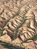
What makes a rolling landscape roll?New study explains evenly spaced ridges and valleys; could help identify signs of life on other planets��ͼ��
rolling landscape ridges and valleys other planets
2009/7/28
The fundamental understanding of the processes that lead to these parallel grooves is not just useful theoretically, but could ultimately allow geologists to predict how eroding landscapes will respon...
�й��о����������а�-��
- ���ڼ���...
�й�ѧ���ڿ����а�-��
- ���ڼ���...
�����ѧ���л������а�-��
- ���ڼ���...
�й���ѧ���а�-��
- ���ڼ���...
�ˡ���-ƪ
- ���ڼ���...
�Ρ���-ƪ
- ���ڼ���...
��������-ƪ
- ���ڼ���...
�������� -ƪ
- ���ڼ���...
֪ʶҪ��-ƪ
- ���ڼ���...
���ʶ�̬-ƪ
- ���ڼ���...
��������-ƪ
- ���ڼ���...
ѧ��ָ��-ƪ
- ���ڼ���...
ѧ��վ��-ƪ
- ���ڼ���...