搜索结果: 1-15 共查到“Flood”相关记录352条 . 查询时间(0.093 秒)
Operational Monitoring and Damage Assessment of Riverine Flood-2014 in the Lower Chenab Plain, Punjab, Pakistan, Using Remote Sensing and GIS Techniques
floods Landsat-8 remote sensing GIS disaster mapping damage assessment Lower Chenab Plain
2024/1/19
In flood-prone areas, the delineation of the spatial pattern of historical flood extents, damage assessment, and flood durations allow planners to anticipate potential threats from floods and to formu...
Increased outburst flood hazard from Lake Palcacocha due to human-induced glacier retreat
Lake Palcacocha human-induced flood
2021/7/27
Human-induced warming is responsible for the retreat of Palcaraju glacier and the associated increase in glacial lake outburst flood hazard, according to an analysis of observations and numerical mode...

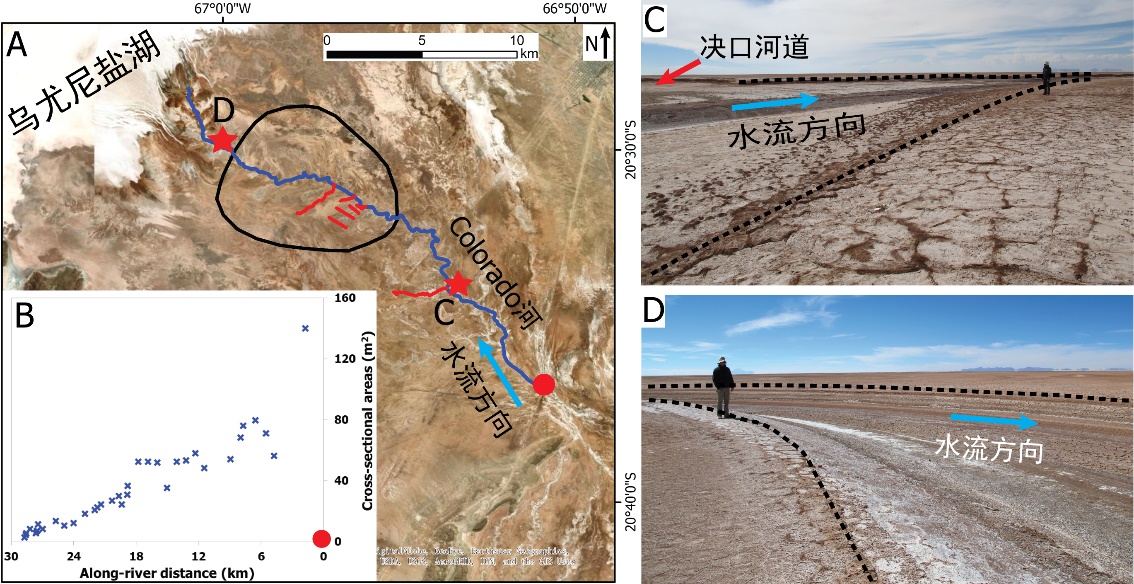
中国地质大学科学技术发展院李嘉光* 等,资源学院. Journal of Hydrology(2020), Digital Elevation Models for topographic characterisation and flood flow modelling along low-gradient, terminal dryland rivers: A comparison of spaceborne datasets for the Río Colorado, Bolivia(图)
精确表征;极低;缓河流;末端;地形;模拟河道;洪水;漫溢
2021/10/15
近日,国际知名期刊Journal of Hydrology在线刊发了中国地质大学资源学院李嘉光副教授团队在陆相湖盆边缘河流末端沉积体系研究的最新成果——Digital Elevation Models for topographic characterisation and flood flow modelling along low-gradient, terminal dryland rive...

Flood Bot: Scientists develop new flood warning sensors(图)
Flood Bot Scientists new flood warning sensors
2020/7/17
Ellicott City, Maryland, suffered devastating floods in 2016 and 2018. The disasters left residents and officials wondering how technology could help predict future severe weather, and save lives and ...

By incorporating the architecture of city drainage systems and readings from flood gauges into a comprehensive statistical framework, researchers at Texas A&M University can now accurately p...
Researchers find collaborative flood modeling process effective
Researchers collaborative flood modeling process effective
2020/2/20
Community collaboration and high-resolution maps are keys to effective flood risk management, according to civil engineers and social scientists at the University of California, Irvine and other insti...
PRELIMINARY INVESTIGATIONS ON FLOOD SUSCEPTIBILITY MAPPING IN ANKARA (TURKEY) USING MODIFIED ANALYTICAL HIERARCHY PROCESS (M-AHP)
Flood Mapping Susceptibility Hazard Risk Modified Analytical Hierarchy Process Ankara (Turkey)
2019/2/27
Susceptibility mapping for disasters is very important and provides the necessary means for efficient urban planning, such as site selection and the determination of the regulations, risk assessment a...
EXPERIMENTAL FLOOD EARLY WARNING SYSTEM IN PARTS OF BEAS BASIN USING INTEGRATION OF WEATHER FORECASTING, HYDROLOGICAL AND HYDRODYNAMIC MODELS
flood early warning WRF hydrological modelling hydrodynamic modelling flood inundation
2019/2/27
The flood early warning for any country is very important due to possible saving of human life, minimizing economic losses and devising mitigation strategies. The present work highlights the experimen...
CONSIDERATIONS ON THE USE OF SENTINEL-1 DATA IN FLOOD MAPPING IN URBAN AREAS: ANKARA (TURKEY) 2018 FLOODS
Flood Mapping Hazard Risk Sentinel Ankara (Turkey)
2019/2/28
Flood events frequently occur due to -most probably- climate change on our planet in the recent years. Rapid urbanization also causes imperfections in city planning, such as insufficient consideration...
MAPPING OF HIGHLY HETEROGENEOUS URBAN STRUCTURE TYPE FOR FLOOD VULNERABILITY ASSESSMENT
Urban Structure Type Object-based image analysis Random forest Support vector machine CART Flood vulnerability
2018/11/9
Vulnerability plays an important role in risk assessment. For flood vulnerability assessment, the map and characteristics of elements-at-risk at different scales are strongly required depending on the...
FLOOD RISK ASSESSMENT OF RIVER KABUL AND SWAT CATCHMENT AREA: DISTRICT CHARSADDA, PAKISTAN
Hazard, Vulnerability, Risk, Geographical information system (GIS), Remote sensing (RS), Disaster risk reduction (DRR), Participatory rural appraisal (PRA) tools, Weighted overlay
2018/11/8
Pakistan is prone to natural hazards including floods, in particular, affecting millions of people each year across the country. Patterns from recent years suggest the intensity of flooding are increa...
SPATIO-TEMPORAL PROCESS SIMULATION OF DAM-BREAK FLOOD BASED ON SPH
Smooth Particle Hydrodynamics GIS Dam-break Flood Spatio-temporal Process Simulation
2018/5/15
On the basis of introducing the SPH (Smooth Particle Hydrodynamics) simulation method, the key research problems were given solutions in this paper, which ere the spatial scale and temporal scale adap...
FLOOD EXTENT MAPPING USING DUAL-POLARIMETRIC SENTINEL-1 SYNTHETIC APERTURE RADAR IMAGERY
Flood Polarimetry SAR Radar Harvey Sentinel-1
2018/5/14
Rapid generation of synthetic aperture radar (SAR) based flood extent maps provide valuable data in disaster response efforts thanks to the cloud penetrating ability of microwaves. We present a method...
ANALYSIS OF THE TONLE SAP FLOOD PULSE BASED ON REMOTE SENSING: HOW MUCH DOES TONLE SAP LAKE AFFECT THE MEKONG RIVER FLOOD?
Remote Sensing Tonle Sap Lake Flood Mekong River Water Storage
2018/5/15
The economic value of the Tonle Sap Lake Floodplain to Cambodia is among the highest provided to a nation by a single ecosystem around the world. The flow of Mekong River is the primary factor affecti...
COUPLING ANALYSIS OF HEAT ISLAND EFFECTS, VEGETATION COVERAGE AND URBAN FLOOD IN WUHAN
Heat Island Vegetation Coverage Urban Flood Change Detection Wuhan
2018/5/15
In this paper, satellite image, remote sensing technique and geographic information system technique are main technical bases. Spectral and other factors comprehensive analysis and visual interpretati...

