搜索结果: 1-15 共查到“海洋科学 System”相关记录155条 . 查询时间(0.156 秒)

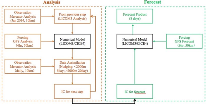
过去二十年,随着高分辨率卫星观测、超级计算机和先进的海洋数据同化方法的发展,海洋环境预报系统得到了快速发展,国际主流海洋预报系统水平分辨率已实现涡分辨(eddy-resolving)。近年来,在国家重点研发计划等项目支持下,中国科学院大气物理所海洋模式团队研发完成了全球涡分辨率LASG/IAP气候系统海洋模式的第3版(LICOM3;Lin et al. 2020;Li et al. 2020),并...

Deep-sea sediments lead to new understanding of solar system(图)
Deep-sea sediments new understanding solar system
2019/10/18
A day is the time for Earth to make one complete rotation on its axis, and a year is one revolution around the Sun -- reminders that basic units of time and periods on Earth are intimately linked to o...
REPEATABLE DEPLOYMENT OF AN OPEN STANDARDS, OPEN SOURCE AND OPEN DATA STACK FOR BUILDING A FEDERATED MARINE DATA MANAGEMENT AND DECISION SUPPORT SYSTEM FOR SOUTH AFRICA
Open standards Interoperability Data Management System CKAN CSW Case Study Distributed Systems Architecture Oceans and Coasts DevOps
2018/11/8
The National Oceans and Coastal Information Management System (OCIMS) of South Africa is a large, integrated IT system for enhancing oceans, coastal and maritime governance, and supporting sustainable...
Carbon isotopes in the ocean model of the Community Earth System Model (CESM1)
ocean model Community Earth System Model
2015/8/11
Carbon isotopes in the ocean are frequently used
as paleoclimate proxies and as present-day geochemical
ocean tracers. In order to allow a more direct comparison of
climate model results with this ...
Shipboard Deployment of a VHF OSCR System for Measuring Offshore Currents
Shipboard Deploymen VHF OSCR System Measuring Offshore Currents
2015/8/10
In July 1994, an OSCR unit was deployed aboard the R/V Columbus Iselin to explore the feasibility of obtaining offshore, vector surface currents from a single platform. The concept is straightforward....
A general approach for quantitative classification of littoral sites has been developed. The approach uses dimensionless parameters to describe the processes in a specific area of physics (e.g., ocean...
Toward a Global Scale Coastal Ocean Observing System
Global Scale Coastal Ocean Observing System Ocean Observing System
2015/8/5
The concept of the Global Ocean Observing System (GOOS) is that of an integrated global network that systematically acquires and disseminates data and data products in response to the information need...
The Ocean Biogeographic Information System (OBIS):An On-line,Worldwide Atlas for Accessing,Modeling and Mapping Marine Biological Data in a Multidimensional Geographic Context
The Ocean Biogeographic Information System (OBIS) On-line Worldwide Atlas for Accessing Modeling and Mapping Marine Biological Data Multidimensional Geographic Context
2015/8/5
OBIS is a component of the Census of Marine Life (CoML) an international program to assess and explain the diversity, distribution, and abundance of marine life. There is no adequate system for retrie...
Development of a Dynamic Biogeographic Information System for the Gulf of Maine
Dynamic Biogeographic Information System Gulf of Maine
2015/8/5
Central to the development of an inventory of marine life and improved conceptual understanding of the mechanisms that dynamically shape species distribution patterns needed for renewable resource man...
H-OBIS:A Historical Dimension to the Ocean Biogeographical Information System
H-OBIS Ocean Biogeographical Information System
2015/8/5
Censuses offer snapshots of a given population at a particular point in time. In presenting a static picture of a dynamic process, such snapshots might reveal much about the composition and spatial di...
The Synthesis of Dynamic and Historical Data on Marine Populations and Communities:Putting Dynamics Into the Ocean Biogeographical Information System (OBIS)
Dynamic and Historical Data Marine Populations and Communities Putting Dynamics Ocean Biogeographical Information System (OBIS)
2015/8/5
The understanding of marine ecosystems requires long-term historical data. Unfortunately, population dynamics data of marine species are much like Hobbes' view of the life of primitive humans: nasty, ...
The scientific goal of the Gulf of Mexico Ocean Monitoring System was to prepare an analysis and summary of the prevailing oceanographic conditions in the Gulf of Mexico and to make it available to in...
Blue Whale Habitat Associations in the Northwest Pacific:Analysis of Remotely-Sensed Data Using a Geographic Information System
Blue Whale Habitat Associations Northwest Pacific Remotely-Sensed Data Geographic Information System
2015/8/3
Detection of stereotypic call sequences are now commonly used to locate blue whales (Balaenoptera musculus) in the North Pacific (e.g., Watkins et al., 2000a; Stafford et al., 1998; 2001; McDonald et ...
In the summer of 1775 a lone frigate, commanded by Bruno de Hezeta, sailed southward along the west coast of a land which would eventually become the United States of America. Hezeta, a first lieutena...
The Coupled Ocean/Atmosphere Mesoscale Prediction System (COAMPS)
Mesoscale Prediction System Ocean
2015/7/31
The U.S. Navy has a need for the analysis and prediction of the atmosphere and the ocean. Routine military exercises can be profoundly affected by variations in the atmospheric temperature, relative h...

